DO YOU KNOW YOUR ZONE?
Know Your Zone is a public education campaign to inform the citizens and visitors of Horry County of the new hurricane evacuation zones and their vulnerability to storm surge. The Know Your Zone campaign was developed as a result of the information contained in the South Carolina Hurricane Evacuation Study (HES) for the Northern Conglomerate that was released by the Federal Emergency Management Agency (FEMA) and the US Army Corps of Engineers (USACE) in 2012.
The campaign also reflects the National Hurricane Center’s (NHC) decision to separate the association of storm surge inundation from the category of storm.
ZONE A

All areas EAST of U.S. Business 17 (Kings Hwy), up to intersection with U.S. 17 (Kings Hwy) and then all areas EAST of US 17 (Kings Hwy) to the Northern County line.
ZONE B

All areas SOUTH of Hwy 707 and Longwood Drive, including all areas in Longwood Plantation (Blackmoor) to the Waccamaw River and all areas EAST of U.S. 17 Bypass (Mark Garner Hwy) to U.S. 17 (North Kings Hwy) and all areas EAST of U.S. 17 (North Kings Hwy) to the northern county line.
ZONE C

All areas between Hwy 701 and Hwy 544, south of Brown’s Chapel Avenue and Hwy 814, plus all areas east of Highway 31 (Carolina Bays Parkway) to Highway 90 and all areas east of Highway 90 to U.S. 17 to the northern county line.
This also includes all flood prone areas along the Waccamaw River and the Great and Little Pee Dee Rivers, as well as ALL mobile home residents within Horry County.
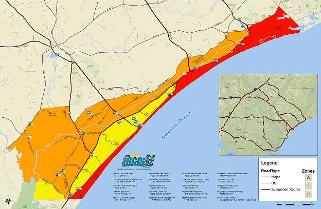
CLICK this map for a copy of the Horry County Zone Map with Evacuation Routes.
Horry County Emergency Management (843)915-5150